Between the Miami Rivers survey is located in southwestern Ohio between the Miami River and the Little Miami River. The entirety of the Between the Miamis survey encompasses all or parts of the modern day Ohio counties of: Shelby, Champaign, Miami, Clark, Montgomery, Greene, Warren, Butler, and Hamilton. The legal description in deeds and surveys all refer to this area as “Between the Miami Rivers Survey” or shortened to "M.Rs." or "M.R.S."
Judge John Cleves Symmes originally petitioned Congress for 1,000,000 acres of land between the Miami Rivers extending northward from the Ohio River on August 29, 1787. Symmes leveraged a certificate of indebtedness given to him by General Washington on his retreat through New Jersey in 1776 in an attempt to garner favorable conditions for his purchase. However, Congress modified this contract, with Symmes’ consent, because Congress did not want Symmes’ tract to interfere with the boundary line established by the Treaty of Fort Harmar.
Symmes and his associates were not able to afford the entirety of the tract they initially petitioned for. Therefore, on September 30, 1794, President Washington issued a US Patent (Deed) for a tract totaling 311,682 acres. The deed conveyed to Symmes 248,250 acres plus a surveying township (23,040 acres), in trust, for an academy. The patent reserved: Fort Washington (15 acres), one square mile near the mouth of the Great Miami; and in each township the following sections: section 16 for schools, section 29 for religion, section 8, 11, and 26 for Congress’s future use.
The Between the Miami Rivers survey is subdivided into six-mile-square townships, ranges and sections, but in a far different manner from those anywhere else in the country. The Symmes Purchase was privately surveyed and is the only original land surveyed in the United States which has ranges running south to north, fractional ranges, and townships running west to east. section numbering is according to the land ordinance of May 20, 1785. In 1802, Congress ordered the remaining land east of the Great Miami River, south of the Greenville Treaty Line, west of the Ludlow Line and the Little Miami River, and north of range III (Military Range) of the Symmes Purchase to be surveyed. Since the Symmes surveyors had already established the unique method of numbering survey townships east-west and ranges north-south between the Miami rivers, government surveyors decided, for the sake of consistency, to continue the methods established in the Symmes survey, thus making the surveys done by Congress and Judge Symmes uniform in the Between the Miamis survey.
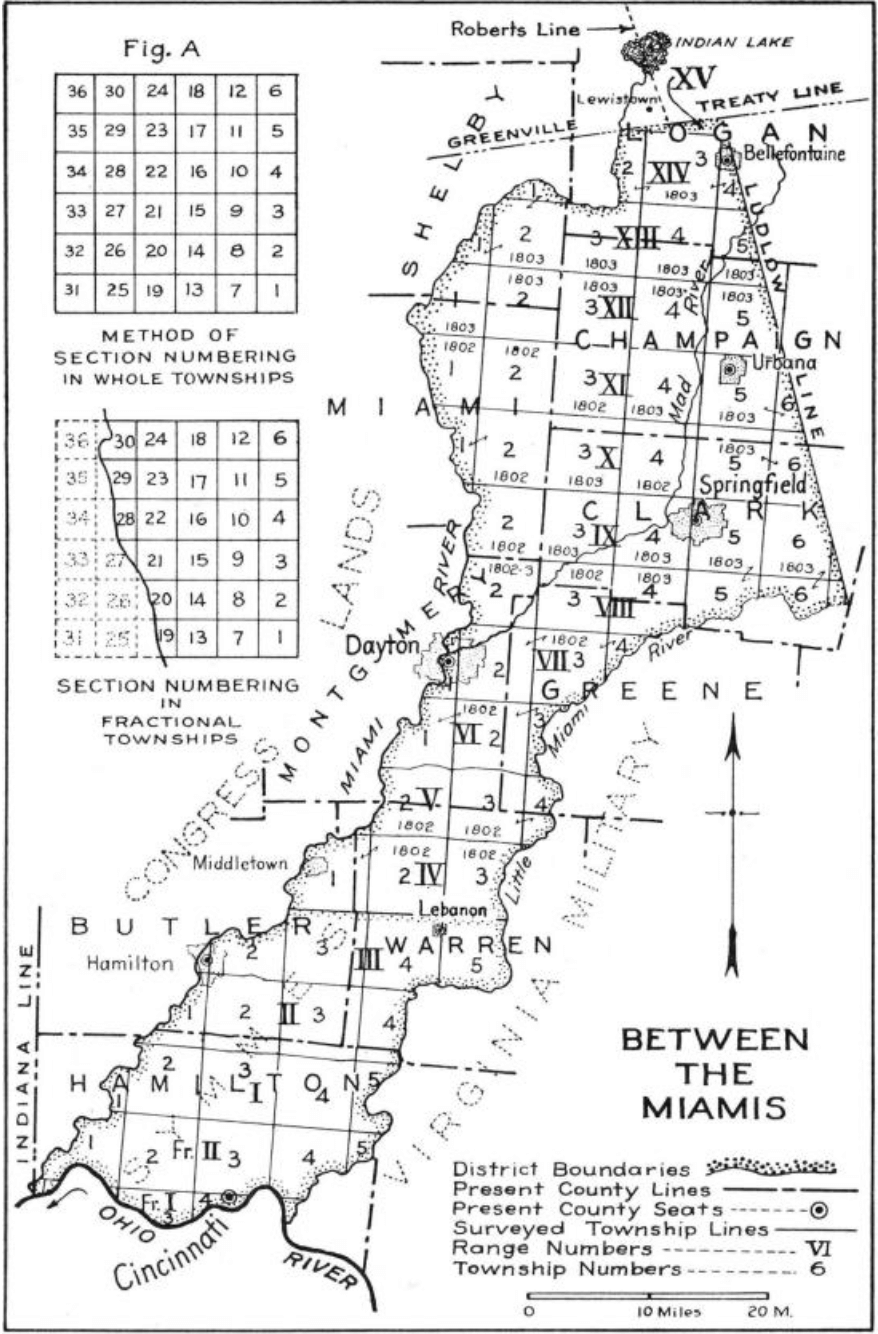
The surveys done within Symmes Purchase are some of the most irregular in the Public Land Survey System (PLSS). Israel Ludlow, Symmes' lead surveyor, ran meridians using magnetic north as opposed to true north, and laid off ranges as lateral rows of townships from the base of the Ohio River, extending northward with the first two ranges being called Fractional Ranges I and II. After Fractional range II, the numbering of ranges starts over from I and continues to the Ludlow and Greenville Treaty Lines, bounding the northmost extent of the tract. Due to the irregularities in the survey, ranges are designated as north of the Ohio River, and townships are designed as being east of the Great Miami river. For example, a brief legal description of a section in the Symmes Purchase could read as follows: section 1, township 2 East, range 3 North. If a section be lying in a fractional range, the brief legal may appear as follows: section 6, township 4 East, Fr. range 1 North.
Townships were subdivided as per the Land Ordinance of May 20th 1785, and are fractional along the Great and Little Miami rivers. In an effort to survey the land as economically as possible, surveyors initially only marked township corners, leaving it up to the purchasers of the property to run the lines to connect the corners. This lead to many irregularities regarding township and sectional lines run in the Symmes Purchase (see survey lines in full Ranges II, III, IV, V, and VI on survey plate). A similar stair-step pattern of township numbering appears here as in the Ohio River Base surveys due to the reliance on a meandering river for a base line. Thus, adjacent townships in a range rarely share the same number designation.